Geographies Of Appurtenant Right
page 1
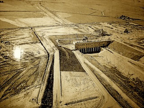
The uniform surfaces of agricultural crops fanning the San Joaquin Valley hold within them the layered strata of multiple histories. Histories of migration, violence, and settlement, to be sure, but also of efforts to profit, legislate, and engineer. Their remains are literally grown into the land. These fields, whose relative nature manifests only as set beside the bold and geometric artifice of the great state and federal highways, stand in repose as a living museum which enfolds the effects of deliberate decisions. The social relations of water, themselves wrought with the strata of such decisions over time, have played a crucial role in the shaping of this fertile land of artifice. Though quite without water may its sweeping vistas to passersby today appear, their leafy exhibition will have been impossible without it. And like the limber fluid that shape-shifts to compliment the contour of its others, the social relations of water too have mutated over time.
Early Europeans settlers found in the valley substantial populations of Miwok and Yokut village dwellers, sustaining themselves by hunting and fishing. Salmon flourished in the north, turtles and shellfish in the southern lakes and marshes. Elk, antelope, grizzly bears, beaver and river otter abounded. As of the mid 1800's California was populated by scarcely 15,000 foreign souls (numbers for indigenous peoples, variously murdered, are unknown) and the great Central Valley, of which the San Joaquin is apiece, appeared wild. Soon enough, gold discoveries at Sutter's Mill in 1848 called thousands to the area – first to engage gold mining, then, the second-best option, farming.
page 2
The water laws and codes of the makeshift mining camps, early farms, and towns were characterized by the common law principle of "first in time, first in right". The informal riparian practices of early frontier settlers vested water rights in the land adjacent to a watercourse, assuring riparians as much use as desired so long as the rights of other riparians were not taken. In the early days, water living in deep aquifers, built up over thousands of years, was plentiful where folks settled, ensuring a tight geographic connection between the watercourse and the land of use. Even the young, bustling city of San Francisco was able to meet its water needs entirely through local springs and reservoirs.
So lovely were the prospects of settlement that foreign souls arrived daily, laying claim to the fertile soils embedded in small water-adjacent plots, willingly given through land development schemes. Even minor diversions were rare. Yet we know that fertile plots would also be settled whose inclusion to claimed land created a fanning out to distances remote from the flows of the underground aquifers, rivers, and streams. And just a year following the formation of Sutter's Mill, the legal doctrine of "prior appropriation" took hold, conferring rights that could be exercised in locations remote from the native watercourse. The San Joaquin Valley Railroad, soon to be equipped with refrigerated cars, laid the land open as a site of transport, opening extensive trade routes. As a fetish and harbinger of the expanding geographies of water use to come, these routes deeply materialized an ethos of interconnection over the course of the 1870's, rendering space a means to the remote, and an object to be overcome. They spawned increasing demands on the California crops through which they ran.
It is during this period of breakneck grabs for wealth and the conquering of space by transport techniques that we find a lively formalization of water rights practices made effective through new legislation. In 1886 the Lux-Haggin decision responded to threats posed by the diversion practices of appropriative rights holders, and formally ensured the rights of riparians. Yet just a year later, in 1887, the Wright Act authorized the constitution of irrigation districts, securing the benefits of appropriative rights holders to non-adjacent watercourses. This marks an important moment in California water legislation, for it is to the establishment of these irrigation districts that the region's rapid agricultural development can be attributed. Because by the early 1900's, the once flourishing underground aquifers were relatively drained, and settled populations naturally began to look to increasing distances for necessary supplies. With the Raker Act of 1913, San Francisco became the first municipality to require resources far and away, leading to the construction of Yosemite dam that would allow the transport of Tuolumne River supplies. That year also saw the writing of the California Water Commission Act, which required that an appropriative right seeker file a formal petition with the State Water Resources Control Board to authorize the construction of works necessary for the diversion of water and the taking and use of the water sought therein. Once the permit was issued, the holder had the right to take and use the water as specified.
page 3
Contemporary writers often characterize "appropriative rights" in terms of their commonness to riparian rights, that is, by reference to their aspects "first in time, first in right", and "use it or lose it". Each of these dimensions of appropriative rights is part of the logic of homesteading incentives used to spur early American homesteaders to settle the land and put it to productive use. He who lays claim to a land where beneficial use of a water resource is applied, acquires a right to use supplies on that land; use must be put to productive purposes on that land, else the right will be revoked.
Yet while the traits ‘first in time', and ‘use it or lose it' are elemental both to appropriative and to riparian rights, the legislative parameters of appropriative rights call up other, more nuanced dimensions of each. Crucially, both riparian and appropriative rights are usufructory. One has a right to use a water resource, not to the corpus of the watercourse itself. Indeed, the right foremost is "appurtenant to" - it "belongs to" - the land on which it is to be used. What the appropriative right introduces is the crucial parameter of diversion from the native watercourse to the land – remote as it may be – to which the right belongs. In this sense, the appropriative right is both resonant and divergent with respect to the riparian right: it maintains the tight social connection between appurtenant land and the bearer of the usufruct, but it also ensures the legitimacy of a geographic severing of the watercourse from the land of appurtenance. It was the formalization of this institution that set the precedent for the intelligibility of the diversion of waters over increasing distances as the 20th century dawned.
And to be sure, like many dreams associated with the western frontier, the once abundant water resources dwindled beneath the seeking activities of men, and were soon to be replaced by hopes for innovations that would keep the prior promise alive. The California legislature supported such innovation when it passed the Central Valley Project Act in the mid 1930's, which authorized the sale of State bonds to finance a giant surface water irrigation project. Finally turning to the Fed amidst the depression era moment, California enrolled The Federal Bureau of Reclamation, resting only momentarily from its construction of the Hoover Dam, which would in the interest of realizing Jeffersonian dreams step up to become its patron. Thus the great Central Valley project, by the brave authorization of Franklin D. Roosevelt, came into being under the direction of the Federal Bureau of Reclamation, bringing with it an intricate and unprecedented set of concrete manipulations upon the land.
The Water Exchange Contract of the 1930's was a water supply agreement with San Joaquin Valley farmers, variously prior riparian and appropriative rights holders to the supply, to exchange the natural reserves flowing through the San Joaquin River watercourse, for Northern water sources. Flows from the San Joaquin River, which in its native state moves westward, would be diverted through what would become the Friant Dam, to create supplies for thirsty crops in the East. In exchange for their loss of native San Joaquin flows, local rights holders were ensured by federal contract that reserves from the North (naturally westward flows into the northerly San Joaquin Delta) would be diverted southward to them, maintaining the rights and allocations to which they had previously been entitled.
page 4
In order for this clever scheme to be possible, a massive configuration of man-made structures would have to be built that would lift the westerly northern sources up nearly 200 feet and divert them toward the south. "The Central Valley Project" is the name of this configuration of structures, and it enables the fanning roadside crops that we see today.
Built between 1947-1951, the heart of the Central Valley Project – the "Tracy" Pumping Plant – was erected to lift the water from the Sacramento-San Joaquin Delta near San Francisco Bay a full 197 feet so that it could then drain by the force of gravity throughout the central valley to its south. Six 22,500-horsepower motors, powered by central valley power plants, would pump water through three 15-foot diameter pipes at a rate of 767 cubic feet per second, which then would be released into the southward canal which moves it 116.6 miles down to the Mendota Pool near Fresno. The Tracy plant also includes the "Tracy Fish Screen", which intercepts the migrant fish sucked upward and southward by the pumps, and returns them to the native Delta channel so that they can try again to reach the pacific. Building the plant involved sinking massive concrete piles into the earth, and legend has it that Tracy is in fact denser and heavier than Fort Knox. Today the plant provides water to 32 water districts representing 2.1 million acres of land within the western San Joaquin Valley, San Benito and Santa Clara Counties. Of the approximate 3 million acre-feet of water distributed, 2.5 million acre-feet are delivered to farms, 200,000 acre-feet to urban areas, including Tracy and cities within the Santa Clara Valley Water District, and 300,000 for wildlife refuges. The flows run through a vast network of earthbound irrigation "turnout" structures, which channel the water through the intricate Euclidean geography of crop users from Tracy in the north to the San Luis Reservoir and Kettleman city in the south, covering a lateral patch from I-5 in the west to Fresno in the East .
The engineered water projects of the 20th century, built to alleviate the water resource disparities between sections of the state, are called "water transfer" projects. They are built to move water from water-rich areas to water-short areas, where it can be put to beneficial use by those who have rights to use it on specific lands. In this sense, the engineered conveyance structures of the great central valley project are monuments to the institution of appropriative right, intensifying the geographic schism between watercourse and appurtenant land. That institution is embodied in the great engineering artifice that enables valley agriculture to continue. Maps of this configuration of the social relations of water, and their geographies, exist. They are capably rendered because the intricate conveyance structures can be seen and touched; and as objects of continuous planning, allocation, and monitoring, their representation from the bird's eye view is a site of ongoing work.
page 5
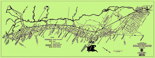
And what is important to note about this particular configuration of social relations is that, despite the geographic schism between native watercourse and appurtenant land that they intensify, the transfer projects of the 20th century maintain a tight social connection, secured through the institution of private property, between the bearer of the appropriative right and the land to which it is appurtenant. With such a tight social connection in tact, the geography of water flows through the conveyance structures is coextensive with the spatial distribution of the lands on which existing appurtenant rights are perfected. Thus, for example, there is stability to the geography of senior and junior rights holders within any given district, because their distribution is land-bound.
However, the social relations of water in the lands covered by the Central Valley Project have begun to undergo a new reconfiguration, not so much as to displace, but rather to move through, its prior form. For as the 20th century twilight internalized excessive growth, debilitating droughts, and the increasing recognition of environmental values, the central valley water conveyance monuments struggle to meet the demands placed on them. Much like the makeshift diversion techniques of the late 19th century were driven to their ultimate inadequacy, the diversion of water over great distances to be put to beneficial use elsewhere meets its own limits. To augment these, markets among competing value uses, a cornerstone of Pete Wilson's Reaganomic water policies and themselves built on the shoulders of 20th century engineering muscle, have begun to emerge. Invisible, such markets nevertheless live within the crops today.
Let us take the example of the Westlands Water District, which spans the territory situated along I-5 to the west and the San Luis Drain to the east, from just South of the city of Firebaugh at the North to the city Kettleman at the South. Each year farmers in this district grow enough tomatoes to make approximately 4.9 billion bottles of ketchup; enough sugar beets to produce more than 70 million pounds of sugar; more than five million pounds of asparagus; and more than 229 million heads of lettuce. "Technically", there are eight hundred separate farms in Westlands, yet operationally these are only three hundred and fifty large farms, or farm "networks". The difference between the technical and operational size of farms emerged as a result of a workaround to an amendment to the 1902 Reclamation act that was made in 1982 in an effort to provide conservation incentives. The amendment stipulates that a farm that purchases water for use on acreage in excess of the 960-acre limit will be charge a much higher price. A workaround to this pricing scheme quickly emerged, however. If you own a large farm in excess of 960 acres, all you have to do is parse it into smaller, 960-acre units. You distribute each unit among family members, and trusts, effectively re-classifying a large-acre farm (and thus large-acre water purchase) into smaller ones, each of these "small" farms remaining within the low-cost limit. One complies with the technicalities of the pricing scheme, while operationally remaining as large as one was before.
page 6
Appropriative rights schemes in Westlands allocate water to two main priority areas. The most senior water right is priority area one, covering 337,000 acres. This land was part of the original Westlands Water District, and under a 1963 contract with the Bureau of Reclamation, is entitled to 900,000 acre-feet of water in a full-delivery water year. Farms with land in priority area one will receive 2.6 acre-feet of water per acre of land in full-delivery years. Priority area two has junior rights. Covering 187,000 acres, this land was originally part of the former Westplains Water District, and was annexed to Westlands. Land in priority area two is entitled to 250,000 acre-feet of water in a full-delivery water year, corresponding to a 1.3 acre-feet per acre. Many of these junior water right farms have very good soils and grow high value tree crops.
The Bureau of Reclamation notifies the various 32 water districts of the Central Valley Project of their respective annual allocations at the beginning of the water year, which runs from March through February. Farmers then apply to the District for an allocation of agricultural water in December for the coming water year. Farmers enter into a contract with the district to accept and pay for the amount allocated to them, and once he purchases an allocation right, a farmer acquires an option that expires at the end of the water year, when the original allocation expires. Farmers must pay for their entire water allocation at the start of the water year, regardless of whether they use it or not.

Those who buy and sell water rights like any other commodity do so on the basis of a simple economic principle. Agriculture is a production process, and irrigated water is an input to production. The value of the use of water as a production input at any given time is variable, that is, it is contingent upon other inputs, such as natural rain water, the fertility of the soil and seeds, and so on. The value of these inputs is determined by the value of the production outputs to which they give rise. If I grow a crop that requires lots of water, and the crop itself commands a high price at the market, the value of the water is high. Economists use the term "value of the marginal product" (the value of the incremental value of the increased output resulting from an additional unit of water) to describe this.
page 7
Now imagine that I am the owner of a smaller, younger farm, and have lower priority rights than you, a senior right holder, have: in a drought year, I will receive a slight percentage of my yearly allocation, and considerably less than you will receive. It turns out that, when you consider the market return on the crops that you are otherwise tooled to produce this year, you discern that the water allocation to which you have a right will in fact actually command a better price than the crop you could grow, if you sold the option to use your water allocation to me. I need a percentage of your water allocation to bring my crop to market, and I determine that the cost of purchasing your right to use diverted water will pay off for me in the end. In effect, we decide that the mutual economic gains of trading a right to use the water outweigh the costs of making the trade, and engage in the transaction accordingly.
San Joaquin Valley farmers engage volatile cash-crop ventures in which products are often perishable and subject to unpredictable fluctuations. Novel strains and new hybrids are constantly being developed to fight the odds of nature and market - so much so that it is nearly impossible to stably represent the geography of coming and going crops. Their seedlings mutate much like homes of poor and ethnically distinct manual laborers who work the land before they are told to turn back home. And the scenario that undergirds the market trading of rights, is one in which a farmer may receive a considerable allocation which, it is becoming apparent by January's end, will not in fact be put to use. He wants to get rid of the allocation he's been given by the end of the water year, and so seeks a farmer, perhaps a junior rights holder, who sees a way he can put that allocation to beneficial use. Note that such a trade requires no changes in the system for conveying water across the network, which is already in place and is in fact a prerequisite for the trade itself. All we have transformed is the option to perfect the right to put the water to use for a specific period of time, on any land that the water resource can reach. Because of the district's great disparity in allocation among the three priority areas, there is an active water market within the district.
Such a state of affairs introduces a transformation of social relations of water and their geographies. Recall that the appropriative right technically belongs to the land to which it is put to use; only incidentally, and by virtue of the presupposition of the institution of private property, is the right accorded to the owner of that land wherein the use is perfected. In this sense, in the early days of its exercise, the spirit of the appropriative right was that is would be conferred to the settler of the land on which it would be used. Thus the institution of the appropriative right in the 19th century context supposes a tight connection between the owner of the land of use (the right holder) and the land to which the use is "appurtenant". In effect, the "right" is effectively granted to a kind of union between the rights bearer and the land of use, through the figure of the property right to the settler of the land on which it would be used, to which the use right technically belongs. The 20th century conveyance structures were built with this in mind.
page 8
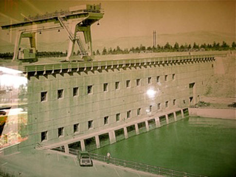
Yet the emergent institution of rights trading, reminiscent of the practice of severing of water resources from their native watercourse, represents a severing of the appurtenant right from the land with respect to which it was originally granted. This means that the sale of a right to an allocation for water increases the volume of water to a new farm where it would not have been allocated before. In this sense, markets for appurtenant rights bring about an ever-shifting geography of appurtenant rights, which themselves flow across the land.
In considering the implications of such emerging market in the mid 1990's, a group of ingenious water management academics from Berkeley University noticed the need for a centralized information system in the valley, which would mediate the trading of water rights. The argument for a centralized information system to mediate trade is closely connected to the economic rationale for trade as such. The value of the marginal product ("VMP") between two potential traders should exceed any transaction costs that attend the creation of the trade itself. But finding transaction partners creates transaction costs. An information system that would enable potential traders easily to identify one another as well as prevailing prices, would create conditions for efficient trade .
The academics built a system called "WaterLink" and deployed it in the Westlands Water District in The San Joaquin Valley. Local journalists and policy analysts hailed WaterLink as a panacea for farmers in the area – "the first and largest electronic water marketing system in the nation" presently serving over "600 farmers covering nearly 600,000 acres of farmland and facilitating trade between Westlands water users of CVP water, contract water, groundwater, and water imported from neighboring water districts. The system lowers water transaction costs by providing market information, reducing negotiation costs and expediting communication between water users and water districts. Hundreds of thousands of acre-feet change hands in a given year."
Our question concerns the implications of such a system for practices of mapping the shifting geographies of appurtenant right that come into being through markets for rights trading. For what is distinctive about the social relations of water in the context of a market for rights trading, is that appurtenant rights themselves are literally diverted over diverse lands with every trade. And the geographies, of what we might call "appurtenant rights diversions", although superimposed over the intricate irrigation networks put in place in the 20th century, are not reducible to them.
page 9
If trades were conducted through such a centralized information system as was envisioned by the masterminds of WaterLink, we can imagine that it would maintain emerging and historical data on the water rights traded, including information about the land to which the right was initially appurtenant and the new land to which the traded right became appurtenant. In that case, such a system would provide the data necessary for constructing maps of trading practices – a cultural achievement not reducible to the goal of reducing transaction costs. We can imagine such maps, showing the flows of rights over the land.
Yet by 2009, it is clear that Westlands farmers are not using WaterLink. Although no Westlands water authority informant with whom I discussed this situation would offer on record a detailed explanation for it, it seems that the uptake of the system was actively undermined by most of the farmers. What they continue to adhere to is an older, word-of-mouth practice among established players in the area, which some have come to call "the coffee-shop method". Indeed, what appears to be occurring is a relatively backroom twofold process. In locating trading partners, farmers engage the "coffee-shop market", because that is where most practices of finding trading partners, negotiating prices, and arranging for the formalization of the trade occur. Peak trading months in the water year occur in February (for sellers to off-load allocated resources for which they have already paid but that they will not be able to put to high-value use), and July (for buyers to compensate for differences between expected and realized climate and to compensate for the limited allocations they received in March. In a study conducted of the then existing informal rights trading market between March 1993 and February 1997, 90% of the potential traders in the district (316 farms out of a total of 350) made trades. Most sellers were owners of large farms, while most buyers were owners of small farms, many of whom bought rights equivalent to their initial district allocation .
The process for conducting the transaction is a "manual" one that follows fairly closely the application process for appropriative rights that was formalized through the California Water Commission Act in 1913: an internal water market transfer is formally initiated by the seller who notifies the district that he wishes some amount of his water allocation to be delivered to another eligible water user within the district. Once an agreement is made between a seller and a buyer, the seller must submit a proposal to the Bureau of Reclamation for a 90-day review period, with a deposit of $3000 to cover administrative costs of processing.
page 10
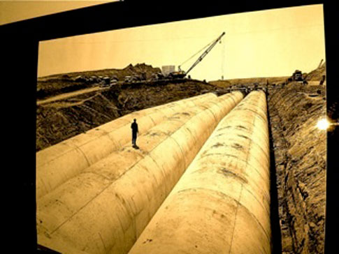
The Proposal issued by farmers has to provide the names and locations of both the buyer and the seller, as well as the location of the area(s) that are to receive the traded water. It must include evidence of the sellers "claim of right" to the quantity being transferred. The proposal must describe the term of the transfer; the facilities required to convey the water; a detailed "consumptive use" analysis to show how the quantity of water being transferred was calculated; evidence as to whether the total amount transferred by the transferor exceeds 20 percent of the contracting district's total water supply; evidence of total contract supply of the transferor's district; documentation of how the water being transferred is being made available (e.g., by fallowing; by use of existing ground water; by conservation techniques); and evidence that requirements of NEPA, ESA, and FWCA, CEQUA, CESA have been met. Once the sale of the rights allocation is approved, the relevant district authority is notified of the traded right; the district then tracks water volumes and records changes in delivery locations, but plays no role in the financial side of the water market transaction. This two-fold process continues throughout the crops of the Central Valley Project today.
The multiple strata of social histories that rest within the crops of the San Joaquin Valley are a continuum of visibilities. Among the crops, though less visible from the vantage point of the road, are intricate networks of water conveyance and irrigation channels that feed the crops that rise above to be seen. Marvels of 20th century engineering skill and continued efforts to manage the land, these networks are well documented by federal and state bureaucracies. Maps allow for the flows of water across the lands to be visualized from a multiplicity of birds-eye views. The recently emergent social relations of water too are embedded in the crops, and give rise to new geographies across the land. Yet these emergent geographies as yet remain intractable to mapping and are invisible. For them to become visible in the context of informal market practices, water authorities, who are aware of the trades, would have to compare the changes in the volumes of water that are allocated to particular tracts of land at one point in time with those allocated by virtue of the trade at another point in time.


